
In a groundbreaking study, scientists from Unpad have used artificial intelligence and satellite technology to track the delicate balance between mining and nature on Belitung Island. The research provides a detailed, decade-long map of forest cover changes, revealing both significant losses and promising signs of recovery, crucial for protecting the island’s unique ecosystems.
This work is vital for achieving UN Sustainable Development Goal 15 (SDG 15): Life on Land, which aims to “protect, restore and promote sustainable use of terrestrial ecosystems, sustainably manage forests, combat desertification, and halt and reverse land degradation and halt biodiversity loss.”
The Battle for Belitung’s Green Heart
Famed for its natural beauty, Belitung Island is also rich in tin, with mining operations dating back to the 1850s. This has created a constant tension between economic development and environmental protection. The island’s forests, including the vital Lalang Mountain conservation area, are home to unique plants and animals and act as a crucial carbon sink in the fight against climate change.
The big question has been: what is the actual impact of mining and other activities on Belitung’s green cover? To find the answer, researchers turned to the sky.
How Satellites and AI Uncovered the Story
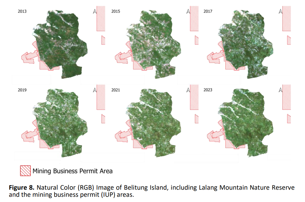
A team from Universitas Padjadjaran and the Karlsruhe Institute of Technology analyzed satellite images of Belitung from 2013 to 2023. Using a powerful AI algorithm called Random Forest Regression, they taught a computer to predict tree cover density across the entire island by analyzing spectral data from NASA’s Landsat and MODIS satellites.
The model was highly accurate (with a 74.6% success rate), allowing the team to classify the island into four categories:
- Class 1 (0-25% cover): Bare land, mines, settlements.
- Class 2 (25-50% cover): Shrubs and grasslands.
- Class 3 (50-75% cover): Agriculture and palm oil plantations.
- Class 4 (75-100% cover): Dense forest and mangroves.
Key Findings: Loss, Recovery, and Warning Signs
The decade-long analysis revealed a dynamic story:
- The 2015 Crash: A sharp decrease in tree cover was detected in 2015, linked to both mining activities in permitted zones and a severe El Niño weather event that caused widespread drought and stress to vegetation, even in protected areas like Lalang Mountain.
- A Promising Recovery: The most encouraging finding was a clear trend of forest regeneration after 2015. Areas that were yellow (denuded) in earlier satellite images gradually turned green again. By 2023, the area of Class 3 (“moderate to high” vegetation) had significantly increased, suggesting successful natural recovery or reforestation efforts.
- A Critical Warning: The study found no areas classified as the densest “Class 4” forest (75-100% cover) throughout the entire decade. This indicates that while recovery is happening, Belitung’s most pristine, old-growth forests may have been lost or severely degraded, representing a critical setback for biodiversity.
A Tool for a Sustainable Future
This research provides more than just data; it offers a powerful tool for conservation.
- For Policymakers: The high-resolution maps can guide sustainable land-use planning, helping to enforce protections for conservation areas and better regulate mining permits.
- For Conservationists: The method allows for near real-time monitoring of forest health, making it easier to identify illegal logging or mining activities quickly and measure the success of reforestation projects.
- For the Public: It highlights the importance of protected areas like Lalang Mountain, which showed strong signs of recovery, proving that conservation works.
“The results highlight vegetation degradation that requires further attention,” the authors noted, emphasizing that this technology is key for “effective forest conservation” on Belitung Island.
By providing a clear, scientific picture of the past decade, this AI-powered map lights the way forward, offering hope and a proven method to ensure Belitung’s development protects the life on its land.
News Source: https://www.scopus.com/pages/publications/105008371650
#UnpadResearch #ForestConservation #SDG15
02/Geo/2025