


A team of researchers has developed a new approach to identify and map urban slums more accurately by combining remote sensing imagery (RSI) and street view imagery (SVI) with deep learning (DL) technology. This innovative method was tested in Bandung City, where nearly one-tenth of the population lives in slum areas.
Traditionally, the Indonesian government has relied on survey-based methods to map slums. However, the results often vary due to differences in surveyor expertise and complex indicators used to define slum conditions. These inconsistencies make it difficult to produce reliable data, which is essential for planning and monitoring urban upgrading programs.
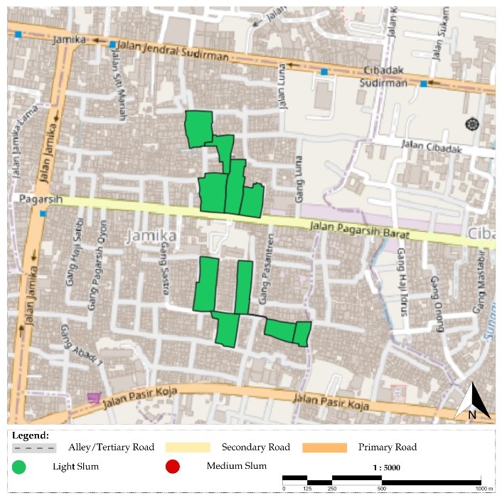
The study compared different deep learning models and found that the FCN-DK network—which integrates RSI and SVI—achieved the highest accuracy at 86.25%. Using this method, researchers identified 2,294 light slum points and 29 medium slum points across Bandung. The findings show that combining satellite data with on-the-ground street views provides a clearer picture of urban environments compared to using either dataset alone.
This improved accuracy matters because it gives policymakers stronger evidence to design better housing, infrastructure, and social programs. It also contributes directly to several Sustainable Development Goals (SDGs):
- SDG 4: Quality Education — By generating reliable data, the research supports educational institutions and communities in learning advanced data science applications for real-world challenges.
- SDG 8: Decent Work and Economic Growth — Accurate slum mapping helps governments and NGOs target investments that create jobs and stimulate inclusive economic opportunities in vulnerable neighborhoods.
- SDG 17: Partnerships for the Goals — The integration of advanced technologies and collaboration among researchers, policymakers, and communities strengthens partnerships needed to achieve sustainable urban development.
The researchers emphasize that while remote sensing provides valuable large-scale data, it cannot fully capture details such as building materials, drainage systems, and street patterns. This is where street view imagery plays a crucial role. By combining both sources, cities can develop a more precise and holistic view of slum conditions.
With further research on efficient data collection and integration methods, this approach could become a powerful tool for cities worldwide striving to build more inclusive, safe, resilient, and sustainable urban areas.
Source: https://www.scopus.com/pages/publications/105011873824#
08/Geo/2025