 Scientists have developed a new, high-resolution map of earthquake risks across Sumatra, Indonesia, using a powerful Bayesian statistical model. This breakthrough offers a detailed look at which specific areas are most vulnerable, right down to the district and sub-district level, providing critical data to save lives and build more resilient cities and communities.
This research directly supports UN Sustainable Development Goal 11 (SDG 11), which aims to “make cities and human settlements inclusive, safe, resilient, and sustainable.” A key target of this goal is to significantly reduce the number of deaths and economic losses caused by disasters, including earthquakes.
Why This Matters for Sumatra
Located on the volatile “Ring of Fire,” Sumatra is one of the most earthquake-prone islands in the world. Its history is marked by devastating seismic events, like the 2004 Aceh tsunami and the 2010 Mentawai earthquake, which caused massive loss of life and infrastructure damage.
A major challenge for disaster preparedness is that not all areas have equipment to record earthquake activity. This means a region with no history of recorded quakes might still be at high risk. This new research tackles that problem head-on by using advanced mathematics to “fill in the gaps” and predict the potential earthquake magnitude in areas without historical data.
How the “Science of Prediction” Works
The research team, led by statisticians and geophysicists from Universitas Padjadjaran, used a sophisticated technique called the Stochastic Partial Differential Equation (SPDE) approach.
In simple terms:
- Data of all earthquake data from 2020 are collected.
- Using a complex statistical model, they interpolated this data—essentially making an intelligent, educated guess about earthquake potential in unmeasured locations based on the data from surrounding areas.
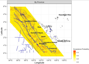
- This process created highly detailed, color-coded maps. The redder the area, the higher the potential earthquake magnitude.
The model also calculated “exceedance probability,” which identifies areas with a high likelihood of experiencing earthquakes above a damaging magnitude of 5.0. The results show that nearly the entire southwestern coast of Sumatra has a 50% chance of such an event, with one area near the Mentawai Islands having a 90% probability.
From Data to Action: Building Safer Communities
These maps are more than just academic exercises; they are practical tools for saving lives and protecting livelihoods.
- For Urban Planners & Policymakers: The data can be used to enforce stricter, earthquake-resistant building codes in high-risk zones, ensuring new infrastructure like schools, hospitals, and homes are built to last. It also guides smarter land-use planning, potentially discouraging dense development in the most vulnerable areas.
- For Disaster Management Agencies: The findings can be used to design targeted early warning systems and tailor emergency evacuation plans. Knowing exactly which sub-districts are at highest risk allows for more efficient resource allocation and community training.
- For the Public: This information can form the basis of public awareness campaigns, helping communities understand their specific risk and learn exactly what to do when an earthquake strikes.
“This high-resolution mapping effectively identifies areas of potential earthquake occurrence, providing critical insights into high-risk zones and emphasizing the need for proactive disaster management strategies,” the authors stated. By turning complex data into actionable intelligence, this research provides a scientific foundation to build safer, more sustainable, and resilient communities across Sumatra and beyond.
News source: https://www.scopus.com/pages/publications/105010201455
#UnpadResearch #SafeEnvironment #SDG11 #EarthquakeRisk
01_Geo_2025